Weather
Weather Dashboard
Summary

min
max
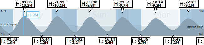
Tide (live)
(estimated)
Next Tides


Issued by the Jersey Met Office.
Shipping Forecast
| Weather | Wind | Visibility | Sea State |
|---|---|---|---|
| Weather | Wind | Visibility | Sea State |
Issued by the Jersey Met Office. The Channel Islands shipping forecast covers the area bounded by latitude 50ºN, the French coasts between Cap de la Hague and Ile de Brehat, and longitude 3ºW.
5 Day Forecast
| Day | Weather/Max | Wind Dir./Speed | Wind Force | UV Level | |
|---|---|---|---|---|---|
| (mph) | ||||
| (mph) | ||||
| (mph) | ||||
| (mph) | ||||
| (mph) |
Tides
Marina opening times
Causeway Access Calculator (for pedestrians)
Location
Click on drop down menu to select location.
Tidal Access
 St Aubins Causeway (5.0M)
closed for pedestrians
(opening )
My Locations / Boats
To find out when your boat starts to float or dry out, enter your boat name and height above chart datum and click on the plus sign.
Similarly, this can be done for other specific locations by entering the location name and height above chart datum and clicking on the plus sign. You may have up to ten locations. The first location will appear in the tides area on the right hand side of each website page.
Here are two examples.
1. Gorey Harbour
The pier at Gorey dries at 4.0m ABOVE chart datum. Therefore at a tide height of 4.0m the harbour will just be awash. A vessel of 1.0m draft wishing to navigate safely with no less than 0.5m under keel clearance (UKC) should add 1.5m to a drying height to calculate the time to safely enter the harbour. Therefore enter 4 + 1.5 = 5.5 to calculate the earliest or latest safe time.
2. Castle Breakwater End passage approaching St Helier
The nearest danger to this track is a rock that is awash just west of the breakwater end. Awash means the rock is at chart datum, or zero height. Therefore the same boat drawing 1.0m and requiring 0.5m UKC should not enter this passage until there is at least 1.5m of tide.
To ensure safe under keel clearance, mariners should also take into account any variable conditions that could affect the calculation (e.g. swell, wind, waves, atmospheric pressure etc.)
* This functionality requires your browser to accept cookies.
Jersey Coastguard transmit shipping forecasts, navigation and weather warnings on VHF channel 82 at the following times:
Shipping forecast (and any gale or navigational warnings)
0645 (local)
0745 (local)
0845 (local)
1245
1845
2245
Gale warnings (on receipt and at these times)
0307
0907
1507
2107
Navigational warnings (on receipt and at these times)
0433
0833
1633
2033
Wind information (speed and gusts at St Helier VTS). Transmitted on VHF channel 18 every two minutes.
All times are in GMT / UTC (except where indicated).
This weather page is provided by Jersey Harbours as a guide only. This V1.0 offering is a free beta version and will be subject to future version upgrades. Jersey Harbours reserve the right to charge a fee for certain aspects of future releases and applications.
Disclaimer
This weather page is intended as a guide only.
The information is provided by Jersey Harbours and other external feeds and while we endeavour to keep the information up to date and correct, we make no express representations or warranties of any kind, express or implied, about the completeness, accuracy, reliability, suitability or availability of the weather and tide information herein contained.
Any reliance you place on such information is therefore strictly at your own risk. In no event will we be liable for any loss or damage including without limitation, indirect or consequential loss or damage, or any loss or damage whatsoever arising from the loss of data or profits arising out of, or in connections with, the use of this weather page.